
SPECIALISED DRONE SERVICES

REMOVING RISK WITH ROBOTICS

Mining and Exploration
We provide a comprehensive suite of services to the mining and exploration sectors, using advanced drone and sensor technologies to deliver accurate, actionable data across all stages of a project.

Our services include:
• Digital Terrain Models (DTM) and Digital Surface Models (DSM)
• Stockpile and tailings storage facility (TSF) profiling
• Volumetric estimation and reporting
• Seeding of overburden dumps and vegetation regeneration support
Digital Terrain Models & Contours
After filtering out above-ground features such as buildings and vegetation, drone imagery can be used to generate Digital Terrain Models (DTMs), where each pixel represents 2.5D information (X, Y, and Z—the elevation of the bare earth surface).
Depending on the project’s objectives, either a DTM or a Digital Surface Model (DSM) can be utilised. These models can be processed with custom contour intervals to produce detailed contour maps, offering enhanced visibility of the site's topography and supporting more informed planning and analysis.
Volumetric Measurements
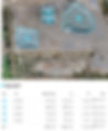
For stockpile volume measurement, drone imagery is captured and stitched together using photogrammetry to produce a high-resolution, interactive 3D map of the site. Once generated, this map can be imported into specialised software to calculate stockpile volumes, measure distances, assess heights, and extract other valuable spatial data. This method offers a safe, efficient, and highly accurate alternative to traditional ground-based survey techniques.
Overburden Regeneration
Operators are required to produce detailed reports for the management of Tailings Storage Facilities (TSFs). These reports must include information on tailings deposition practices, any ongoing reclaim operations, the geometry and maximum height of the TSF, as well as site-specific features influencing stability and containment.
Tailings Storge Facilites Profiling
Once a mine has reached the end of its operational life, the site enters the reclamation phase. Reclamation involves rehabilitating the land to a stable and natural condition, often with the goal of restoring the original landscape or preparing it for alternative uses such as industrial or municipal development.

Drill Collar Pick-Up
For planned exploration drilling programs, we can accurately set out new drill hole locations and record the coordinates of existing drill collars with centimeter-level precision. This capability is maintained even in the most remote and challenging environments, ensuring reliable spatial data to support geological modelling and resource planning.